

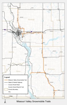
(Emmons and Burleigh Counties)
![]()
![]()
![]()
 Snow Conditions:
Updated: April 1, 2026
Amount of Snow: 13-21 inches
Recent Snowfall: 0 inches
Snow Depth: 0-2 inches
Current Weather for Bismarck
Trail Condition:
Trails are closed for the season. Here is a link to the section of ND Century code regarding Snowmobile Laws: ND Century Code Snow
Trails:
Wilton Trail:
Sterling Trail:
Lincoln Trail:
Moffit Trail:
Zeeland Trail:
Ashley Trail:
Communities: (Click Here for Accommodations)
Bismarck, Baldwin, Wilton, Menoken, McKenzie, Sterling, Moffit, Hazelton, Linton, Strasburg, Hague, Zeeland and Ashley.
Total Trail Miles:
135.8 Miles
Connecting Trails:
None
Descriptions:
The trailhead is located 1.5 miles South of I-94’s Exit 61 on Bismarck Expressway. This trail runs east 22 miles along Highway 10 to Sterling, where food and gas are available. The trail then turns south to Moffit which is located 10 miles south of Sterling along Highway 83. South of Moffit are the towns of Hazelton (15 miles) and Linton (20 miles) which have gas, food, and lodging available. The trail also travels north of Bismarck along Hwy 83 to Wilton.
Contacts:
Don Schmidt – Northern section from Moffit to Wilton
701-214-9773
Francis Wald – Southern section from Moffit to Ashley
701-321-0868
Clubs:
Beaver Valley Sno-Goer’s
PO Box 394
Linton, ND 58552
Rough Rider Snowmobile Association, Inc.
PO Box 4162
Bismarck, ND 58502
Membership Brochure